River Basin
The Danube River Basin is Europe's second largest river basin, with a total area of 801,463 km². It is the world's most international river basin, flowing through the territory of 19 countries. The ecosystems of the Danube River Basin are highly valuable in environmental, economic, historical and social terms, but they are subject to increasing pressure and serious threats of pollution from agriculture, industry and cities.
The Danube River Basin is home to 79 million people with a wide range of cultures, languages and historical backgrounds. However, the increasing human impacts, pressure and serious pollution from agriculture, industry and municipalities affect the water supply for communities, irrigation, hydropower generation and industry, as well as opportunities for transportation, tourism and fishing. The Danube River and many of its tributaries form the spawning grounds for many fish, but they receive various degrees of treated wastewater from many different sources, which ultimately ends up in the Black Sea, affecting the nutrient levels in a large portion of its waters. In this sense, the River Danube is the single most important contributor to nutrient pollution in the Black Sea.
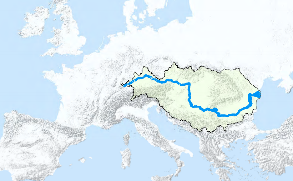
The Danube River Basin can - based on its gradients - be divided into three sub-regions: the upper basin, the middle basin, and the lower basin (including the Danube Delta).
The Upper Basin extends from the source of the Danube in Germany to Bratislava in Slovakia.
The Middle Basin is the largest of the three sub-regions, extending from Bratislava to the dams of the Iron Gate Gorge on the border between Serbia and Romania.
The lowlands, plateaus and mountains of Romania and Bulgaria form the Lower Basin of the River Danube. Finally, the river divides into three main branches, forming the Danube Delta, which covers an area of about 6,750 km².
Upper Basin
The Upper Danube has a rapid current of between 8 and 9 km/hour, due to the pronounced gradient of the river bed. Its tributaries bring in flow from the northern side of the Alps as well as drawing in flow from the southern side of the Central European Highlands. Depths vary from 1 to 8 metres.
Middle Basin
In its middle section, the Danube looks more like a flatbed river, with around half the speed of the Upper Danube, with low banks and a bed that reaches a width of more than 1.5 km. Only in two stretches - at Visegrad (Hungary) and at the Iron Gates - does the river flow through narrow, canyon-like gorges.
The Danube enters the Little Alföld Plain immediately after emerging from the Hungarian Gates Gorge near Bratislava. There the river slows down abruptly and loses its transporting capacity, leading to the deposition of enormous quantities of gravel and sand on the riverbed. This deposition has formed two large islands, one on the Slovakian side of the river and the other on the Hungarian side. Both have a combined area of about 1,869 km², and are home to some 190,000 inhabitants in more than 100 settlements.
The Danube then flows past Budapest and across the vast Great Alföld Plain until it reaches the Iron Gate Gorge. The riverbed is shallow and marshy, and low terraces stretch along both banks. Deposition has formed a large number of islands along these reaches, including Csepel Island near Budapest. In this stretch, the Danube is joined by the waters of three major tributaries - the Drava, the Tisza and the Sava - which nearly triples its flow.
Lower Basin
Beyond the Iron Gates, the Lower Danube flows across a wide plain; the river becomes shallower and broader, with several major islands, and the current slows down considerably. The tributaries that enter the main river along this section, including the Iskar, the Olt, the Yantra, the Siret and the Prut are comparatively small and only account for a modest increase in the total flow rate.
The river finally divides into three main branches near Tulcea in Romania, some 80 km from the sea, forming a delta extending over an area of about 6,500 km².
The Danube Delta
The three main channels flowing through the delta are the Chilia, which carries 63% of the total flow; the Sulina, which accounts for 16%; and the Sfintu Gheorghe (St. Geroge), which carries the remainder. Only the 62-km canalised and dredged Sulina Channel is navigable. [more]
Main Tributaries of the Danube
(in descending order according to the locations of confluences)
The Inn is the third largest of the Danube’s tributaries by discharge, and the seventh longest. At the confluence in Passau, it contains more water than the mainstream of the Danube itself, but its catchment area of 26,130 km² is less than half as big as that of the mainstream so far. The main tributary of the Inn is the River Salzach.
The River Morava/March enters the Danube from the north. Its catchment area of 26,658 km² includes parts of the Czech Republic, Slovakia and Austria, within a basin lying between the Bohemian Highlands, the Carpathians and the Pannonian Plain. This region is ecologically valuable, due to its diverse flora, fauna, habitats and landscapes.
The Drau/Drava
The Tysa/Tisza/Tisa
The Save/Sava
The Iskar is the largest Bulgarian tributary of the Danube, with a total length of 368 km and a catchment area of 8,684 km². Its headwaters are located up in the passes of the Rila Mountain: The mainstream flows through the outskirts of Sofia, and through the Balkan Mountains.
The Siret River Basin is the third-largest catchment area of any Danube tributary, and is situated to the east of the Carpathians. The Siret flows from its source in Ukraine into Romania, joined along the way by the waters of sub-tributaries (Suceava, Moldova, Bistrita, Trotus, Barlad and Buzau).
The Prut River is the second longest (950 km) and the last major tributary of the Danube, with its confluence located just upstream of the Danube Delta. Its source is in the forests of the Ukrainian Carpathians. Later the Prut forms the border between Romania and Moldova.


